
In the (Convergence) Zone
A Ship Journey Through the Deep Tropics

Disneyland, step aside! We’ve found a new Happiest Place on Earth: a narrow band of the tropics that stretches around the globe, featuring both the sunniest skies physically possible and the most tireless storms and rain. It’s called the Intertropical Convergence Zone and it features its own cast of friendly, roaming characters in the sky. And it’s just as easy to snap a picture with one as it is at Disney, though certainly harder to shake their hands.
I recently returned home from a 50-day research cruise on the Bay of Bengal in the Northern Indian Ocean, where I was part of a team of scientists studying the ocean and atmosphere during the onset of the Indian summer monsoon (a.k.a. the rainy season in that region of the world). In the middle of the cruise, we sailed south into the deep tropics, almost to the equator, and entered the Intertropical Convergence Zone (or ITCZ, as it’s most often called). This was a phenomenon that I was familiar with only through reading papers and looking at satellite imagery, so I was thrilled to finally experience its prolific cloudiness firsthand.
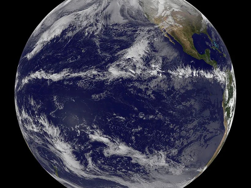
This band of endless thunderstorms near the equator is where the Earth is actively exporting the monumental amount of heat that it absorbs from the sun, sending it from the surface to the upper atmosphere and toward the poles. In the tropics, the sun is nearly directly overhead for much of the year, and all of that solar radiation warms the near-surface air, causing it to rise and generate storms that reach up to the tropopause and spread away from the equator. The ITCZ is (remotely) more famous in the tropical Pacific Ocean, where the “convergence” in its name becomes more clear. The trade winds in each hemisphere push air toward the equator from both the north and south, leaving that air nowhere to go but up, creating a belt of thunderstorms that can stretch from Indonesia to Ecuador.
On our cruise, we traveled a long line south through the Bay of Bengal during the pre-monsoon season, when the weather over India is at its most sweltering. Lucky for us, the temperature over the Bay is tamed by the influence of the ocean, which keeps the air around 86F. Yet the air is always close to saturation, so the humidity is palpable and your sweat does precious little to cool your skin. In the shade, you could almost call it pleasant, but the same cannot be said in the direct sun. I spent much of the day on the back deck of the ship tending to the instruments beneath our shade structure and keeping a vigil over the side of the ship, waiting for storms to brew.
As we sailed into the deep tropics, it was clear that the lower level of the atmosphere was hungry to convect, with vigorous bubbling of the cumulus at the top of the boundary layer, as seen in the timelapse below. But the clouds couldn’t get very high before losing buoyancy and sinking back down to where they began. This lid couldn’t last for long, though, and within a couple days, the horizons were peppered with storms erupting to the upper atmosphere.
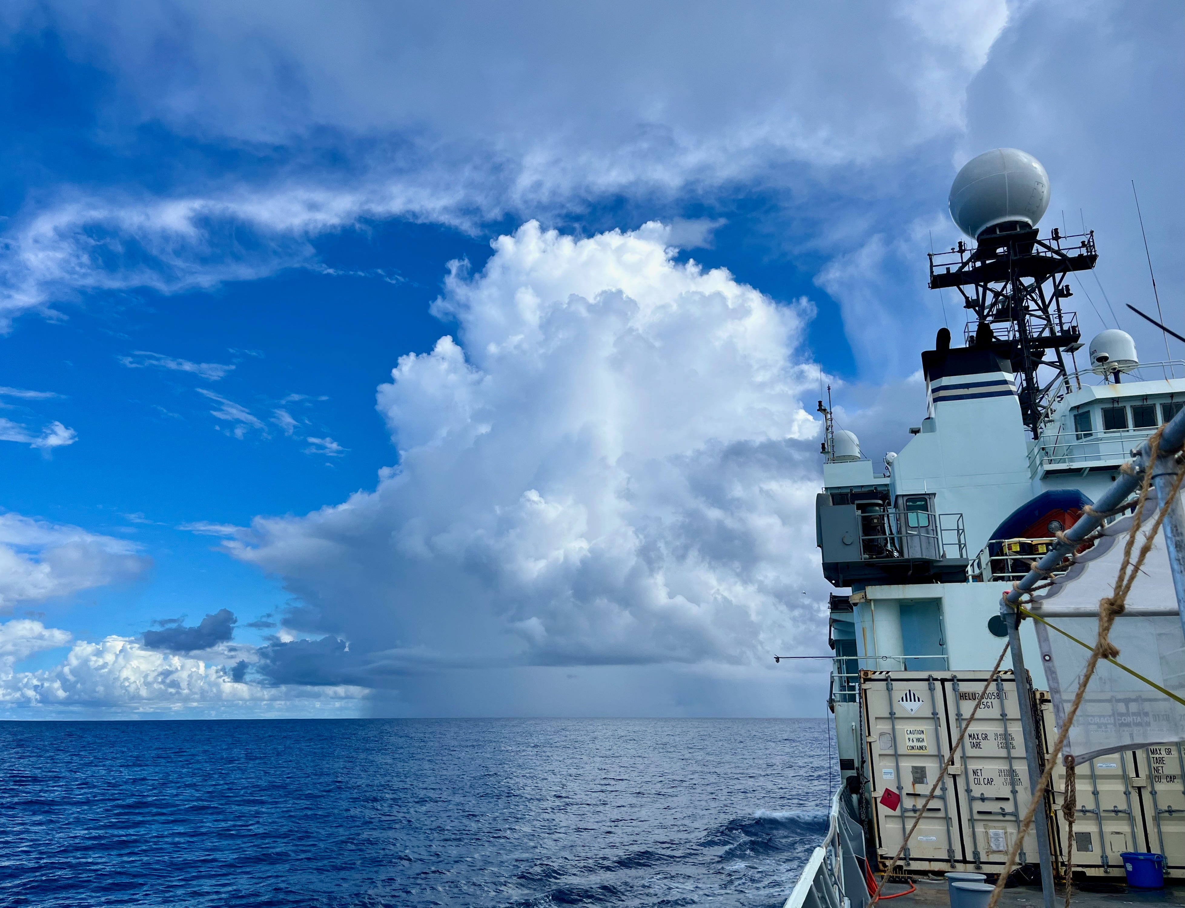
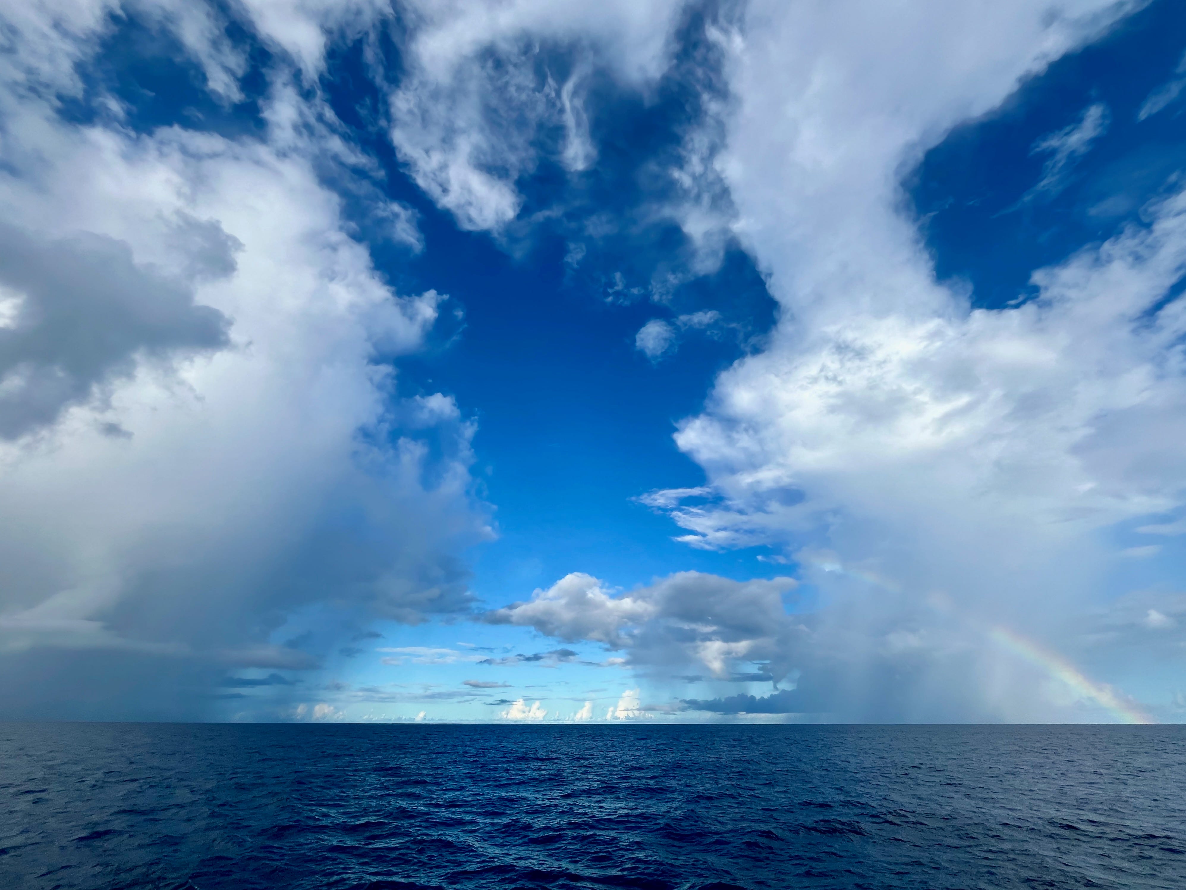
Although we were surrounded by storm clouds, the sky was mostly blue. The cumulonimbus pillars created heavy rainfall underneath, but only in small patches, leaving most of the sea surface calm and sunny. When the clouds erupted close enough to us, we would feel the cold, gusty winds that fall from the storm and spread outward in what’s aptly called a “cold pool”. These spreading signals let us locate storms even at night, when a sudden drop in temperature and shift in wind direction would point toward a nearby cumulonimbus churning away.
The timelapse below shows one of these storms developing several updrafts behind our ship, putting up burst after burst until hitting a stable layer and flattening its top into an anvil. There are two primary areas of rain: 1) directly below the storm, where there is heavy rain visible just above the horizon as solid gray mass, and 2) about halfway up the storm, below the developing anvil, where it looks like a white mist, evaporating as it falls. In the area of heavy rain below the storm, the wind is likely gusting to 45 mph, the air has cooled by 8 degrees F or so, and the ocean waves are picking up and aligning the surface currents into windrows. But from our vantage point a few miles away, the day is calm and sunny. Facing a different direction, one would think that the weather was quite unremarkable.
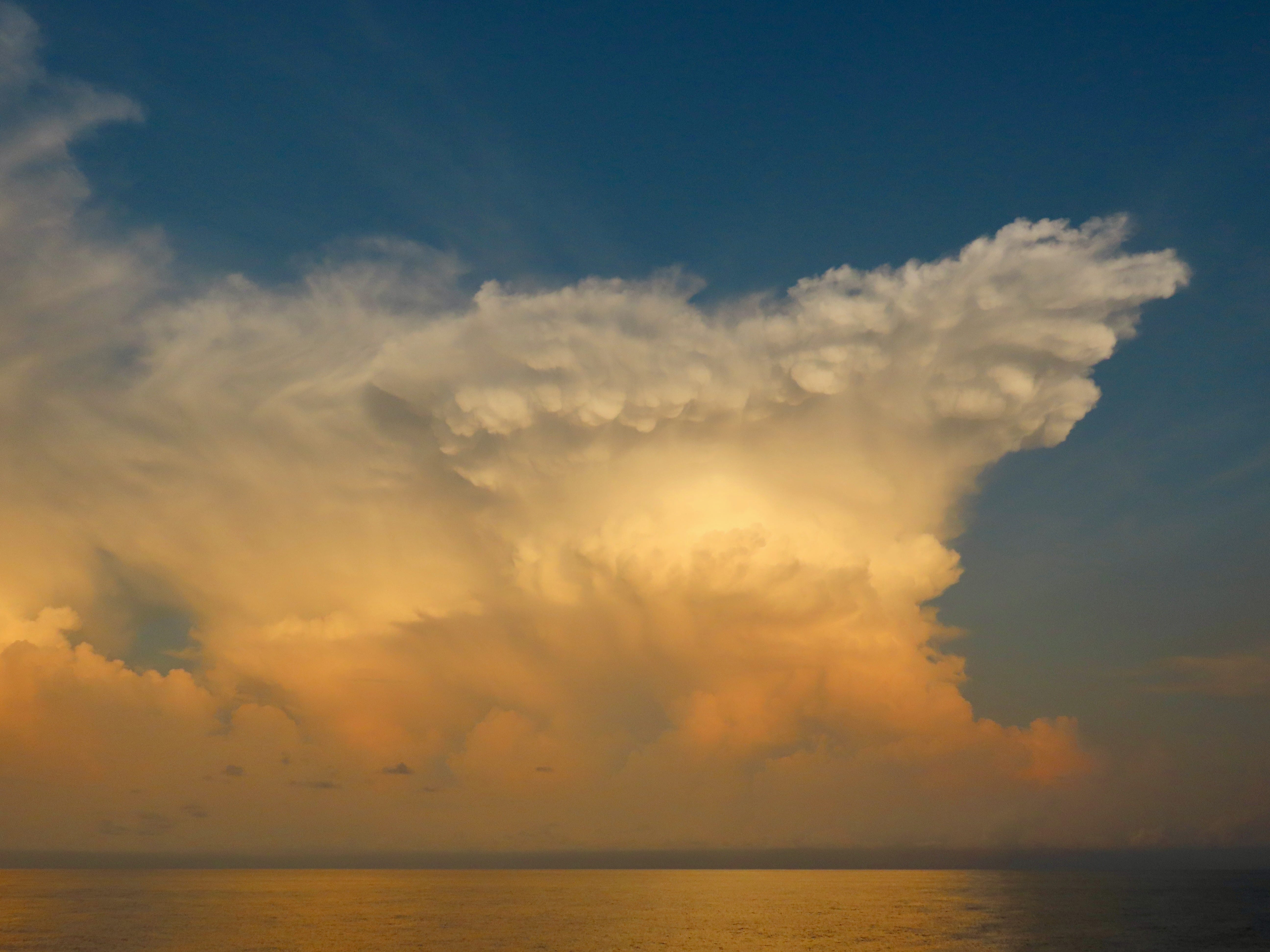
The cloud in the next timelapse was the best one that I saw on the cruise, and one of the best that I’ve ever seen. I spent about 45 minutes holding my phone up (and forsaking dinner) to watch it develop from a row of modest cumulus clouds to a sky tapestry dramatically painted by the setting sun. At the very end of the timelapse, the Earth’s shadow climbs the cloud, quickly extinguishing the color and leaving it as just another gray mass in the sky, as if this performance had never occurred.
I stood on the side of the ship in awe of this cloud, taking a timelapse with one hand while snapping photos with the other in an attempt to somehow capture this transitory tropical event. Seeing a cloud like this makes me want to do something but I haven’t yet figured out what that thing is, other than to be a good witness.
The constant contrast between blue skies and towering storms created strange and beautiful lighting conditions throughout the days, where bright, clear skies in some directions would dramatically oppose the dark, stormy skies in another. As we passed below and around storms throughout the day, the quality of the light would change from hour-to-hour, with relief arriving every time a storm’s anvil conspired to block the direct sun shining on our working decks.
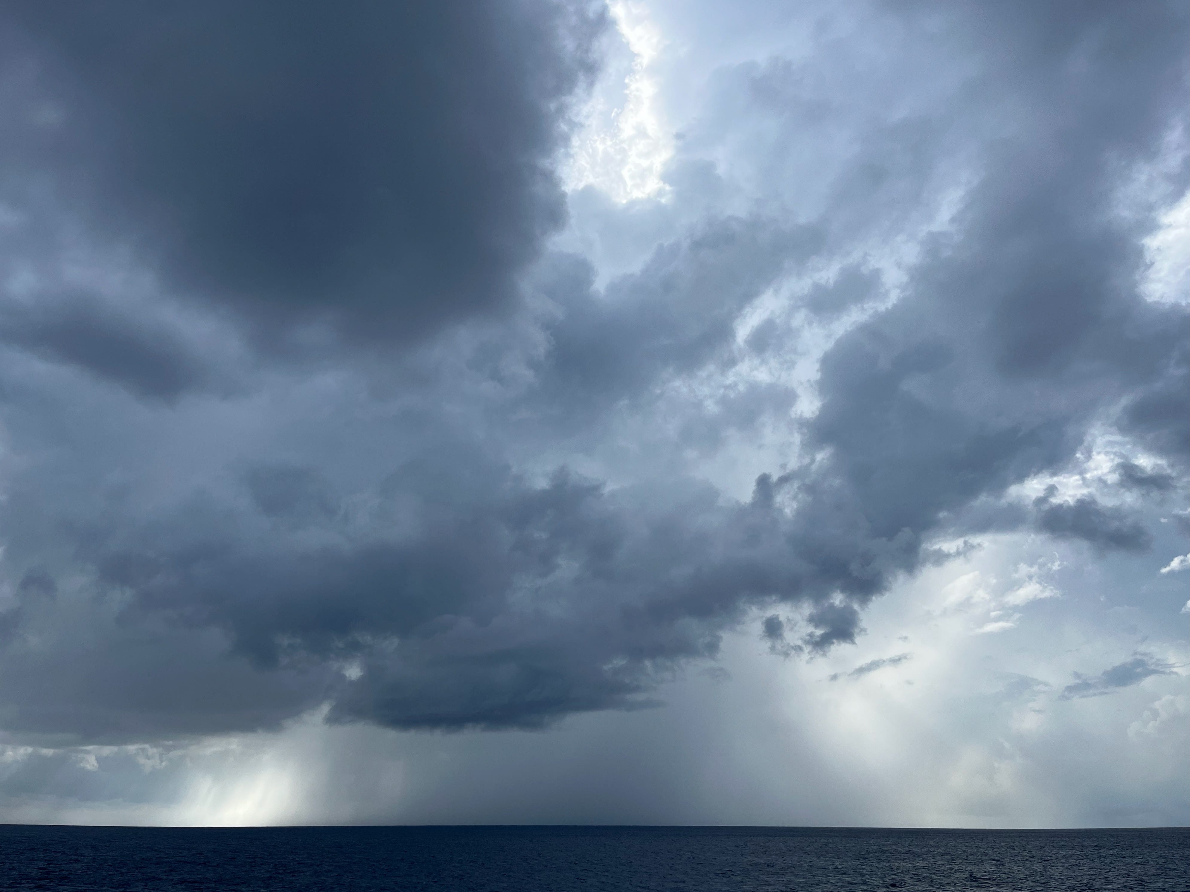
Rainbows were frequent, too, appearing and disappearing with each passing storm as an evanescent signature.
As we finished our initial survey of the Bay of Bengal, we traveled back north, leaving the ITCZ behind. But the Indian Ocean is special, as it hosts the Indian monsoon, which causes the band of clouds and rain to march north and south with the arrival and departure of the summer season1. So within two weeks, the ITCZ came to us as the Indian Ocean passed through its transition into the summer monsoon season. The band of convection traveled up the Bay and passed our ship on its way to the continent, where it is currently laying down storm after storm, leaving the hillsides green and the air finally cool. When summer ends, the band will return southward to the equator, extending again across its station in the vast ocean.
Someday I hope to visit the incarnations of the ITCZ in the Pacific and the Atlantic as well, as surely each has its own personality and cast of cloudy characters that bring sunny and stormy joy to each sector of the deep tropics. But for now, I’m grateful to have witnessed the Indian Ocean ITCZ in-person to put a face to the immense web connecting our oceans and continents with slender lines of rain, wind, and clouds.
In this post, I am following the traditional view of interpreting the monsoon core as the north-south migrating ITCZ during the summer season. Another more modern view is to see the monsoon and ITCZ as distinct; the former establishes itself in the northern hemisphere during the summer while the latter remains in the southern hemisphere year-round. In either interpretation, we were where the fun was happening in the Indian Ocean.
Great time lapse videos and the descriptions are so helpful for what to look for in them!
I love the satellite picture of the storm clouds along the equator. Have never seen a picture like that before. Fascinating!